On-On-Da-Ga
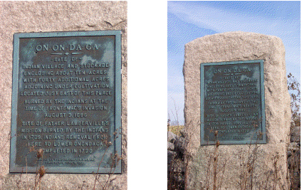
|
Current Sign Text |
On-On-Da-Ga |
|
Problematic issues |
- The generic "Indian" was used as late as 1933 rather
than identify the Onondaga. |
|
Location |
Located on NYS 91 about 1 mile S of Jamesville. East side, 1.1 mile S of NYS 173 |
|
Significance |
This marker identifies the western edge of a large area of Onondaga settlements. Other markers referencing this area are Deep Springs and Indian Hill. |
|
Indigenous Place Names for Site |
|
|
Circumstances of Marker Placement |
Erected by the Syracuse Chapter S.A.R. (Sons of the American Revolution) and State of New York in 1933. Bronze tablet on boulder. "The State Historic Marker Program began in 1926 as a program of the State Education Department to commemorate the Sesquicentennial of the American Revolution. Over 2,800 of the small, cast iron site markers ... were erected statewide during the duration of this program (1926-1939)." |
|
Additional Information |
From Struggle for a Continent by John Ferling- Count Louis de Buade de Frontenac was "sent to America to implement a plan" to destroy the Iroquois and therefore take over New York from the English. Frontenac was 76 years old when he "led an army of 2,000 into Onondaga country, near present day Syracuse." From The Ambiguous Iroqouis Nation by Francis Jennings- "Frontenac invaded the Onondaga, where he destroyed houses and crops." |
|
Sources |
1. New York State Museum, "Outreach: State Historic
Markers", [www.nysm.nysed.gov/services/marker/
srvmarker.html, downloaded January 23, 2011] |
|
Review Details |
Sue Eiholzer, 2011 |