Techiroguen
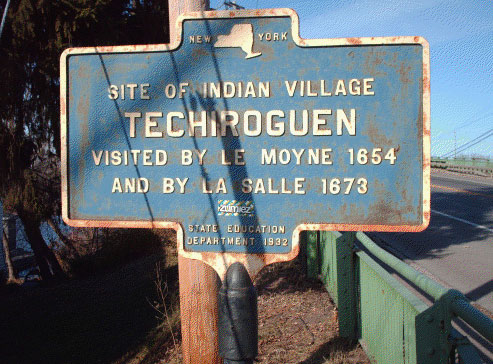
|
Current Sign Text |
New York |
|
Problematic issues |
The marker leaves out the importance of this site in indigenous economics and
trade. |
|
Location |
Located in Brewerton, NY, on U.S. 11 and Bennett Street, at the south end of the Brewerton Bridge, near the place where the Oneida River flows out of Oneida Lake |
|
Significance |
Techiroguen was an Onondaga fishing village. |
|
Indigenous Place Names for Site |
The village was called Techiroguen, while the locality was known as Oh-saha-u- ny-tak se-ugh-kah ("where the waters run out of Oneida Lake")(3). |
|
Circumstances of Marker Placement |
A local Brewerton historian, J.E. Milton, paid for this marker and 17 others (4). The marker was erected in 1932 as part of New York State's Education Department commemoration of the Sequicentennial of the American Revolution. Over 2,800 of the small, cast iron site markers were erected statewide during the duration of this program (1926-1939)"(5). |
|
Additional Information |
During the 18th century, the French, English, and colonists saw this crossroads as strategic and sought to wrest control of this route – even though it was Haudenosaunee territory. During the French and Indian Wars, British and French troops crisscrossed this area. In 1759, the British built a fort at this site to defend colonies against the French. In 1779 Colonel Van Schaack and his troops encamped near here on their way to burn Onondaga villages. |
|
Sources |
(1)W.W. Clayton, "History of Cicero, NY", History of Onondaga County, New York,
D. Mason & Co., Syracuse NY, 1878. [http://history.rays-place.com/ny/onon-
cicero-ny.htm] |
|
Review Details |
Gail Bundy, March 20, 2012 |